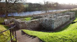
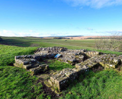
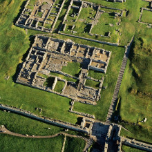
Chesters Bridge Abutment - Hadrian's Wall

Chollerford, Hexham, Northumberland NE46 4EN, UK
1-99 Years
Paid

Description

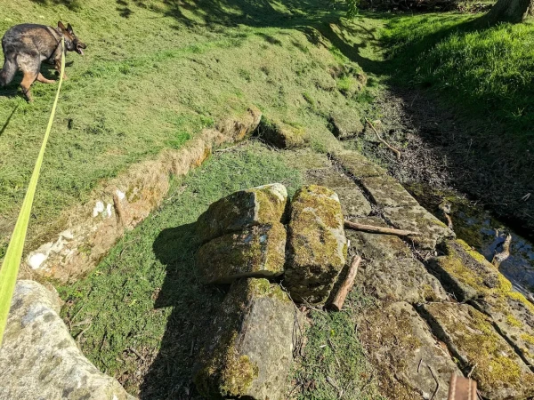
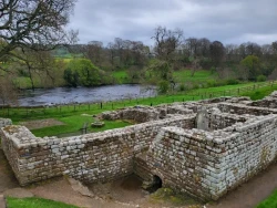
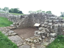
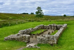
Close to Chesters Roman Fort in Northumberland are the remains of a Roman bridge across the North Tyne. On the eastern river bank you can see evidence of two successive bridges:  an early one that just carried Hadrian's Wall, and a second, much larger one, that carried the Military Way - the road that serviced the Wall. This fine bridge, one of the most remarkable survivals on Hadrian's Wall, proclaimed the power and prestige of the Roman emperor and his empire. 

The east abutment at Chesters was part of a large road bridge built in about AD 160 to carry the Military Way (the road accompanying Hadrian’s Wall) over the river North Tyne. The abutment, from which the easternmost arch sprang, incorporates the pier of an earlier and much smaller bridge which was part of the original construction of Hadrian’s Wall. The later bridge continued in use until the end of the Roman period and was demolished in the AD 670s to provide building materials for St Wilfrid’s church at Hexham.

Free Entry. If you are looking for Best place for day out with kids and families then this is the perfect destination offering fun, adventure, and unforgettable memories for everyone.

Features

  • Paid
  • Host birthday parties: No

Features

  • The east abutment at Chesters was part of a large road bridge built in about AD 160 to carry the Military Way (the road accompanying Hadrian’s Wall) over the river North Tyne. The abutment, from which the easternmost arch sprang, incorporates the pier of an earlier and much smaller bridge which was part of the original construction of Hadrian’s Wall. The later bridge continued in use until the end of the Roman period and was demolished in the AD 670s to provide building materials for St Wilfrid’s church at Hexham.
  • The remains of the two successive Roman bridges at Chesters encapsulate some of the main developments in the history of Hadrian’s Wall. 
  • The First Bridge: The original Roman route between Corbridge and Carlisle, now known as the Stanegate, crossed the River North Tyne by means of a ford, or more probably a timber bridge, situated half a mile or more downstream from Chesters.
  • When Hadrian’s Wall was built, the Stanegate continued in use. The purpose of the bridge at Chesters was to take the walkway along the top of the Wall across the river. Construction, or at least preparation of the site, began in the first or second season of Wall building (probably in AD 122 or 123).
  • The first bridge was built entirely of large stone blocks bound together with iron clamps set in lead, as is shown by the pier embedded in the east abutment of the later bridge. The easternmost of its arches was 4 metres wide; if this first bridge was the same length as its successor, it would have had nine arches. Such a large structure would have taken longer to complete than most of the other installations on the Wall.x
  • The bridge was presumably left standing during the period from about AD 140 to 160 when the army on Hadrian’s Wall was sent north to hold the new defensive line on the Antonine Wall in Scotland.

Facilities

Parking: There is an English Heritage managed car park at Chesters Roman Fort, a 20 minute walk from the Bridge Abutment along the roadside.

Birthday Parties

Offer Birthday Parties: No

Open any reasonable time during daylight hours.

Address: Chollerford, Hexham, Northumberland NE46 4EN, UK

Post Code: NE46 4EN

Council: Northumberland

County: Northumberland

  • Road Access: 1⁄2 mile south of Low Brunton, on A6079.
  • Bicycle Access: Find this site on The National Cycle Network.
  • Parking: There is an English Heritage managed car park at Chesters Roman Fort, a 20 minute walk from the Bridge Abutment along the roadside.

0

0 Reviews

Rating breakdown

5
80% Complete (danger)
0
4
80% Complete (danger)
0
3
80% Complete (danger)
0
2
80% Complete (danger)
0
1
80% Complete (danger)
0

Get the best blog stories into your inbox!