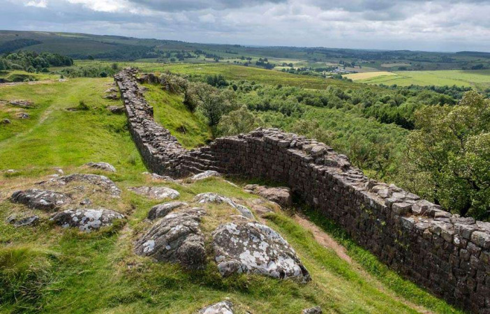
Walltown Crags - Hadrian's Wall

Description

Walltown Crags - Hadrian's Wall this is one of the finest places to see Hadrian's Wall, where it snakes and dives through dramatic countryside along the crags of the Whin Sill. Not only is the Wall itself especially well preserved here, but it also shows how the soldiers who built it coped with the presence of large outcrops of natural rock – sometimes incorporating it into the Wall, and sometimes almost butting up against it. At one end is Walltown turret, which unusually was first built as a freestanding tower. 

At one end is Walltown Turret (no. 45a) which was one of many such watchtowers built along the Wall for small groups of soldiers to shelter in and keep watch. Unusually, this turret might have originated earlier, as a freestanding watch or signal tower.

Free Entry. If you are looking for Best place for day out with kids and families then this is the perfect destination offering fun, adventure, and unforgettable memories for everyone.

Features

  • Free
  • Host birthday parties: No

Features

  • History of Walltown Crags Wall and Turret: The Romans built Hadrian’s Wall from AD 122 to define the north-west boundary of their empire. One of the best places to see it is on Walltown Crags, where a well-preserved section of Wall crosses dramatic open countryside along the Whin Sill, with magnificent, panoramic views.
  • At one end is Walltown Turret (no. 45a) which was one of many such watchtowers built along the Wall for small groups of soldiers to shelter in and keep watch. Unusually, this turret might have originated earlier, as a freestanding watch or signal tower.
  • Building the Wall: Three Roman legions, each consisting of some 5,000 soldiers, undertook the building work on Hadrian’s Wall, beginning in AD 122. These legions – the 20th Valeria Victrix, based at Chester, the 6th Victrix, based at York, and the 2nd Augusta, based at Caerleon – provided working parties, rotated periodically, leaving others to fulfil military needs in their bases and elsewhere in Britain.
  • The Wall on Walltown Crags: At Walltown Crags a conserved section of Hadrian’s Wall runs along the edge of the uplifted rocky outcrop of hard dolerite known as the Great Whin Sill, which has created cliffs and steep slopes to the north.
  • The turrets of Hadrian’s Wall: The original design for Hadrian’s Wall comprised a continuous high wall and a V-shaped ditch, stretching 80 Roman miles (117.5km) from Wallsend on the river Tyne in the east to Burgh-by-Sands on the Solway Firth in the west. The builders incorporated about 160 turrets along the Wall, providing vantage points to monitor movements of people, especially to the north.
  • Walltown Turret (45a): Turret 45a is unusual in comparison with most others on Hadrian’s Wall. Like other turrets, it has a typical rectangular interior ground plan, about 4.1 by 3.9 metres, walls up to 0.95 metre wide and traces of a doorway towards the east end of the south-east wall. However, the Wall meets the turret walls at distinct angles, whereas turrets are usually perpendicular to it and partially incorporated into the Wall thickness. Most significantly, the joints where the Wall and turret meet are vertical and straight, implying that the turret existed before the Wall was built up to it.
  • Excavations at the turret: Discovered in 1883, the turret was partially exposed three years later and fully excavated in 1913. It was re-excavated in 1959 during the conservation of Hadrian’s Wall on Walltown Crags (see below).
  • Saving Hadrian’s Wall: Public pressure to preserve sections of Hadrian’s Wall, including some parts threatened by active stone quarrying, gained momentum in the 20th century and especially in the 1930s. At Walltown Crags, with quarrying encroaching from east and west, destruction was averted in 1943 when an area was defined for preservation. It was finally secured by the government paying compensation to the quarry owners.

Facilities

Parking: There is a Northumberland National Parks car park nearby. NNP charges apply.

Price

Price: Free

Birthday Parties

Offer Birthday Parties: No

Open any reasonable time during daylight hours.

Address: Greenhead, Brampton CA8 7JD, UK

Post Code: CA8 7JD

Council: Northumberland

County: Northumberland

  • Road Access: 1 mile North-East of Greenhead, off B6318.
  • Bicycle Access: Find this site on The National Cycle Network.
  • Parking: There is a Northumberland National Parks car park nearby. NNP charges apply.

0

0 Reviews

Rating breakdown

5
80% Complete (danger)
0
4
80% Complete (danger)
0
3
80% Complete (danger)
0
2
80% Complete (danger)
0
1
80% Complete (danger)
0

Get the best blog stories into your inbox!